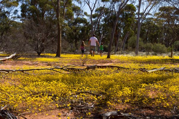
Now’s the time to see the Wheatbelt’s bush at its best as it has burst into colour. The Wheatbelt Way self-drive is beautiful in wildflower season. You’ll find interpretive signage at 24 locations, new user friendly camper kitchens in Trayning, Beacon, Bencubbin and Mukinbudin caravan parks. Well organised free camping sites at Minnivale, Mangowine, Mt Marshall, Mollerin, Billiburning, Beringbooding, Elachbutting and Westonia. Jump in the car and go for a drive next week, you’ll be so glad you did! Make sure you don’t miss these wildflower hotspots and don’t forget to call into the local Visitor Information Points located at the local shire offices or community resource centres to get the inside knowledge on where to find the wildflowers at their best! For more information visit www.wheatbeltway.com.au or download the Wheatbelt Way App that has Wildflower information and Audio Tracks with information and dramatised stories to guide you on your journey. We had a dry run through June and July, but August is off to a wetter start – and it’s just what the wildflowers needed! More and more blooms are popping up at our wildflower hotspots, and with more rain on the horizon, we’re in for a stunning season ahead.

SHIRE OF DOWERIN
- At the Tin Dog Creek Reserve located right on the edge of the Dowerin town site near the information bay opposite Rusty the Tin Dog there’s an array of birdlife and flora. Pick up a walk trail map from the visitors centre at the Community Resource Centre on Stewart Street or at the Shire of Dowerin Office on Cottrell Street and head to the Tourist Information Bay on Goldfields Road and follow the green or red Rusty signs to enjoy the long or short walking trail. There are many educational signs for your interest, the Tin Dog Creek Bird Hyde and some resting points along the way. Why not take a stroll along the Tin Dog Creek Walk Trail and pass through a dense stand of Melaleuca – Honey Myrtle Species. It is one of the richest Melaleuca areas and has remarkable diversity in this reserve.
- From Dowerin head out past the Wheatbins and take the Amery-Benjaberring Road gravel road for 8km and explore historic Minnivale Townsite surrounded by the Minnivale Nature Reserve. Many species of orchids including Donkey, Bunny, Blue and Pink Fairies, Clown, Leek and Spider can be found in the Minnivale Reserve during winter and spring. The yellow and white varieties of Verticordia, red-flowered Eremophila maculata and the purple-flowered Calytrix can also be found here. The pink, white and yellow everlastings are common during spring throughout the Minnivale Reserve. On the roads leading to Minnivale from Dowerin, the Pink Pin-Cushion Hakea, Grevillea petrophiloides or Pink Pokers and white-flowered Grevillea biformis, can be seen on the road verges.
- Namelcatchem is a 600acre CALM Class A1 Reserve, 17km east of Dowerin. This reserve is abundant with pink, white and yellow everlastings from August to October. Several species of orchids are found here, as well as hakea, grevillea and verticordia species.
SHIRE OF WYALKATCHEM
- Wyalkatchem has some of the loveliest reserves, including Walk-A-Wyal Trail (crosses golf course surrounding the town) & Wyalkatchem Reserve all within walking distance from town & RV Friendly Caravan Park. Call into the Wyalkatchem Visitor Information Centre for maps and more information.
- Korrelocking Reserve is a 7km, 5min drive or 20min bike ride from the town of Wyalkatchem. Korrelocking is dominated by mature Salmon Gum and Gimlet woodland and a wander through the reserves find rare orchids, sundew, everlastings and fauna including Kangaroos, Echidnas, Dunnarts, Blue Breasted & Red-Capped Robins. It is a popular picnicking place for local people especially during spring when it abounds with wildflowers.

SHIRE OF TRAYNING
- Billycatting Hill Nature Reserve located 27km east of Trayning, is a delight this year, with flowering shrubs and orchids. Explore the two marked walk trails and learn from the “meet the plants” trail side signs along the way. White flowered sundews (Drosera sp.), insect eating plants like the dampness are at the base of the rocks. See if you can spot the rare Darwinia chiddarcooping with its amazing red flowers dripping in nectar. Carpets of pink and white everlastings are scattered throughout the reserve and can be seen from the roadsides.
- The Gnamma’s located 18km north of Trayning on the Bencubbin road is in bloom with orchids including spiders, donkeys and fairy. Birds and other wildlife frequent the rock pools. The perimeters of gnamma holes are also good places to search for orchids, and other wildflowers.
SHIRE OF NUNGARIN
- Whether you’re on the trail of pioneers or wildflowers, Nungarin packs some surprises. The Nungarin Town site Heritage Trail goes through the surrounding Salmon Gum Woodland which is bloom as well as including historic buildings in the region, including McCorry’s Old Hotel, the Post Office, Nungarin Hotel and the Anglican Church. Head 16km north if Nungarin to Mangowine Homestead which has a great botanical walk. Be transported back to the 1870s. Discover the story of pioneers Charles and Jane Adams, explore its 10 hectare natural bushland setting and see the first stone and mud brick homestead in its original condition, when it served as an inn for travellers heading to the Goldfields. Explore Eaglestone Rock, 20km north of Nungarin surrounded by York Gum Woodland which abuts the rock which has stands of red Kunzea pulchella adding patches of colour against the backdrop of Lake Brown (saltlake). A good picnic area with toilets and camping facilities. Also visit Talgomine Reserve 20km north east of Nungarin a great wildflower spot with picnic familities and Danberrin Hill 20km south of Nungarin at your leisure to and smell the fragrant Vanilla Bush (Grevillea sp.) in bloom and view blankets of pink and yellow everlastings and the woodlands are filled with the delicate blooms of orchids.. Time your visit to coincide with the first Sunday of the month and you can also indulge at the Nungarin Wheatbelt Markets.
SHIRE OF WESTONIA
- Go 100km north of Westonia to Elachbutting Rock see the spectacular Wave Rock formation and Monty’s pass, the wattles, senna, grevilleas and hakeas are in full bloom. At Sandford Rock Nature Reserve the Silver Mallee (Eucalyptus crucis subspecies crucis) and Purple Peacock Beetles are some of the rare species found on these granite outcrops at this time of year. Sandford Rocks Nature Reserve is situated 10km north east of Westonia along the Boodarockin road. It protects 806ha of granite outcrop, pools, wildflowers, scrub and woodland. It has many diverse species of flora and fauna. The Sandford Rocks Discovery Trail guide booklet is available from the Westonia Shire Office.
- Wander the walk trail through the magnificent tall Red Morrell Eucalyptus Woodland of the Westonia Common starting out from the Westonia townsite just outside the entrance to the Caravan Park you will find the start of the Woodlands and Wildflowers Heritage Trail. This 4km walk trail will take you through the Westonia Common woodland and back to town past historic points of interest. The Westonia Common is 5600ha of salmon gum, morrell and gimlet woodlands of exceptional quality and area. Whether your interests lay with wildflowers, birds, woodlands or fossicking through old miner’s dumps, you are sure to find a place that captures your imagination in the Common.
SHIRE OF MUKINBUDIN
- The Mukinbudin to Bonnie Rock roadsides, have wattle, senna, hakea, quandongs and some purple dampiera. On and around the rocks at Wattoning Historical Site located 12km north of Mukinbudin, you’ll find purple calytrix, yellow hibbertia and red flowering kunzea. Mauve leptospermum [tea tree] is flowering profusely around the base with donkey orchids hiding among thick undergrowth.
- At Beringbooding Rock located 72km north east of Mukinbudin finds the pink tea tree, Acacia’s, Grevillea’s Hakea’s, Calothamnus, Eromophila, Cassia, Quandongs, Sandalwood and the native orchids all in flower. Beringbooding Rock has great picnic and free camping facilities, interpretative signage and a marked walk trail.
- Weira Reserve is 13km east of Mukinbudin and boasts a picturesque limestone breakaway with a gnamma hole. Native orchids can be found along the walk trails and keep your eye out for the Red Capped Robin. There are a few patches of pink everlastings on Masefield Road on the way to Elachbutting Rock.

SHIRE OF MT MARSHALL
- On the Mukinbudin-Bencubbin road the Pityrodias (native foxgloves) are flowering. Call into Marshall Rock and wander the walk trails of Mt Gardiner and Mt Marshall, The reserve remains a great place for bushwalking, bird watching and viewing the wildflowers. One of the best reasons to visit the site has to be the spectacular views from the top of Marshall Rock where one can see Lake McDermott, vast agricultural lands and even the Bencubbin Wheatbins. The Reserve covers 1.4 square kilometres and is bounded by private farming land on every side. Around Bencubbin is looking fantastic. Plenty of wattles are out in flower and great rainfall in the last two months should expect some good displays of wildflowers so call into the Bencubbin Community Resource Centre and ask where the best wildflowers are.
- Head to the town of Beacon Sandalwood and Quandong are fruiting heavily. Orchids including Spider and Fairy can be found around the granites. Masses of yellow flowering acacias are surrounded by a carpet of pink, white and yellow everlastings. Grevillia, Hakea, Eremophila, and many more species in bloom. Rare and endangered Sand paper wattle can be seen in the Beacon Botanical park and at Billiburning. A 600 species Herbarium can be studied at the Beacon Visitor Centre (Mon-Fri).
- A further 33km north to Billiburning Rock. This rock is part of quite a relatively undisturbed bushland area; it is one of the largest outcrops in the area and provides many opportunities for birdwatchers. It has attractive wildflowers and native fauna can often be seen. A good view from the top of the rock to appreciate the beautiful sunsets offering many photographic opportunities. As the rock is quite close to the Vermin proof fence you often have good sightings of wedge-tailed Eagles, Budgerigars, Black Cockatoos, Purple-crowned Lorikeets, Major Mitchells and Mallee Fowl. The area surrounding the rock is a good picnic and camp area and hiding in the undergrowth you will find Spider, Donkey and Snail Orchids. Stop in at Beacon Central for Visitor Information and more information on specific local wildflower locations.
SHIRE OF KOORDA
- Koorda has some very colourful tall dark mauve Verticordia sp. are on display on the roadsides as you get close to the Koorda townsite. Call into the Koorda Community Resource Centre (Mon-Fri) for the local knowledge of where the small red Darwinia Rosea commonly known as the Koorda Rose can be found and while there view the local Wildflower Interpretation Display. Head out 16km north east of Koorda to the Koorda Native Flora Reserve to stroll the guided walk trails. Drive 20km north of Koorda to Newcarlbeon Rocks to enjoy a spring picnic or camp out amongst the carpets of pink and white everlastings. Or even further 45km north of Koorda town site to Mollerin Rock Reserve masses of pink and white everlastings can be found on display here along with panoramic views from the top of the rock. There are picnic, camping facilities and a toilet.


